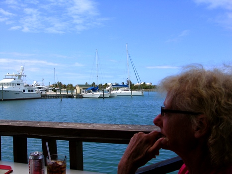
April 25, 2010
26.1204N 80.1081W Fort Lauderdale, Florida.
At the marina.
Tied up. Safe and secure. Civilization!! Its already noon and the
girls are not yet shopping! There is hope!
Actually the trip
to the laundry is much more important. We are all out of clothes and
we are beginning to offend the olfactory systems of our neighbors....
the marina manager was unsure if we were not in fact people who sleep
under the adjacent bridge rather than true “yachties”. Since
tomorrow we become civilized and smelling better, we shall rent a car
and shop all day. Won't that be fun!
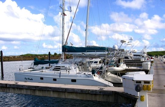
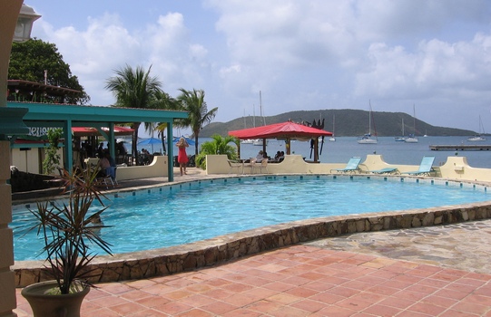
 Ft.Lauderdale: Big Houses, Big Boats and... errr .. Babes.
April 24, 2010
26.1202N 80.1082W Fort Lauderdale, Florida.
Made it back to
the US! And now we have five days to shop! What can be more exciting?
Stores everywhere! And the view is great, see above!
The Gulf Stream
crossing was just a great day of sailing, no motoring required. The
navigating offset for the Gulf Stream was rather interesting but we
ended up right where we wanted to be which is a much desired result
after an all day sail, the alternative being rather disquieting.
Tonight we grabbed the last mooring ball left in town and after
tyeing up to it we discovered why it was the last free ball..... thus
it is off to the marina in the morning to get a slip and begin trip
recovery operations.
April 23, 2010
25.315N 79.1000W Cat Cay.
Last stop in the
Bahamas. Next it's Ft. Lauderdale and a lot of time cleaning and
fixing the ship. Today was another day of motor sailing as there has
been no wind. We are hoping the same conditions continue for the Gulf
Stream crossing tomorrow as wind from the wrong direction can make
the crossing a bit of a mess. We are anchored just off the small
airport here but it is not a busy place so sleep will be no problem.
We are all looking forward to the jump over to Florida.
April 22, 2010
25.315N 78.1000W At sea.
We motored all day
(no wind) and at the appropriate adult beverage time we stopped.
Right in the middle of the ocean! (But... we are on the Great Bahama
Bank so it is not very deep.) It is a rather strange thing to be
spending the night, alone, in the middle of nothing but water, so we
did the proper thing... a few drinks, bar-b-qued some steaks, watched
the shuttle take off from Florida and then hit the sack for an early
departure.
O.K. the shuttle
thing (we think it was the shuttle) was spectacular and a fluke of
timing .... it certainly was impressive even from a hundred miles
away.... it was after all heading toward us! Watched the boosters
blow off, the second stage blow off and follow them all the way to
the sea. We hope the shuttle made it, we have no way of knowing out
here.
April 21, 2010 25.0752N 77.3126W Nassau, Bahamas
Our big splurge of the trip! We went over to Paradise Island and tied up for the night at the huge Atlantis Hotel Marina right along with all the other 200 foot yachts.... Actually there are two of us 42 foot Manta's here...... see.......

With the nights
tie up we get full reign of all the facilities here at the hotel. And
do they have things to do.... a zillion pools and water slides and
stuff .... biggest water park anywhere that I know of. We did manage
not to break anything personal during the numerous near death
experiences. Some of those suckers are tall and drop quick and
sometimes go back up again! Nothing like getting airborne in an inner
tube.... in a dark tunnel!
Good thing we are
leaving tomorrow morning for Bimini and preparation for the big Gulf
Stream crossing.... Don't know that us elder folks can handle all
that terror.
Looks like we
should make Lauderdale by this weekend, after Saturday the weather
gets kinda bad for a crossing.
April 20, 2010 25.0748N 77.3126W Nassau, Bahamas
Checked into a marina, which will remain nameless, not to expensive and now we find out why. As most of the Bahamas seems to be the hotel and other amenities are defunct, broken, or non-exisitant. It is however located across the street from a big super market so its off to shopping we go!
April 19, 2010 24.7487N 76.8377W Allen Cays, Bahamas...
Iguanas. Lots and Lots of Iguanas. And not just regular Iguanas but huge “pre-historic” iguanas. Says so right here in the Bahamas Cruising Guide. See Iguana go after Mike.... See Mike run for the water (Guess what.... Iguanas swim!) Yea! Fun with Iguanas.
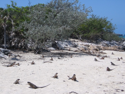 Just discovered: this is called a LOUNGE of Lizards!!!!
April 18, 2010 24.3981N 76.6337W Exuma National Park, Warderick Wells, Bahamas.....
Perfect sailing yesterday, twenty knot winds, semi-smooth seas, sun, killer day. Arrived at the park mid afternoon, grabbed our mooring and went ashore. It was great – no shopping! Hiked to the top of Boo-Boo mountain, all 60 feet of it. When global warming melts all the ice this country is toast.
Today we start the trip to Nassau, a three day island hopping adventure. We do not know what the weather is going to do, it does not look promising this morning, but press on we must as we have discovered this AM that we are out of eggs and other essential life sustaining objects. We much reach Nassau soon so we can .... you betcha' ..... go shopping!
April 16, 2010 24.1852N 76.4585 Big Majors, (near Staniel Cay), Bahamas....
As you can see
from the coordinates we have not moved far... about 6 miles further
north. An easy morning sail, don't want to over do it. It is still
rough on the ocean side of the islands and a bit windy but not so bad
on the “inside” (wes... ourt) side. We are going to anchor here before
jumping back into the ocean tomorrow when the wind and seas are
supposed to subside a bit more. Not much to do here but relax and
read and of course watch the beach pigs. They do get excited when a
dingy gets close to the beach. Do not believe we will be going to the
beach to lay in the sun today. Just noticed.... These pigs swim!
Before your dingy gets to the beach the pigs are swimming out to
(Greet? Attack?) you. These are very fat pigs... how many cruisers
are missing in this area? What about those loose dingies that are
found?
We have decided to
have an early dinner and get out of here early in the morning.
April 15, 2010 24.1007N 76.4031 Black Point, Great Guana Cay, Bahamas....
Big day today! Trash dump followed by home made pizza at a house/restaurant/internet (picked up the special bread we ordered yesterday at Lorraines but seems Lorraine forgot to pay the internet bill so we went off to find another “hot spot”...... and lunch). Bought a bag of ice and it was back to the boat for more rest. What a day: Garbage, Pizza and Ice. We are exhausted.
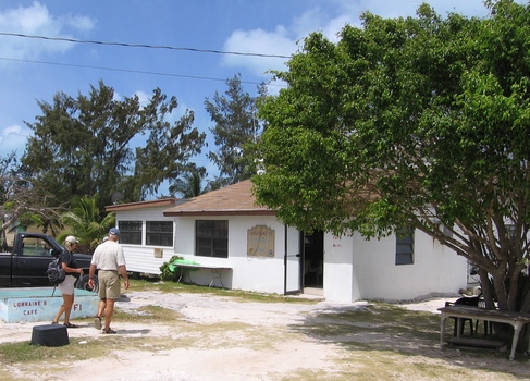 Lorraines resturant and WIFI!!!!!!! Yea!!!!
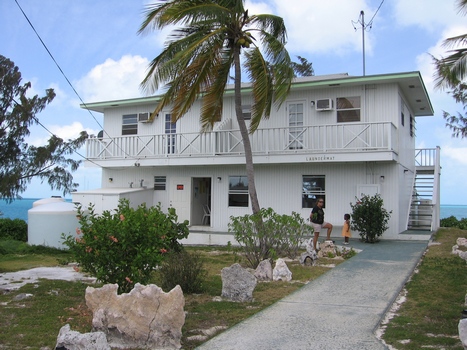 The "LAUNDERMAT" in Black Point.
April 14...... 24.1007N 76.4031 Black Point, Great Guana Cay, Bahamas....
A fun sail to Black
Point with winds in the mid twenties, we were at times over eleven
knots boat speed.... and bashing in another washing machine (large
seas from the starboard side). The wind is still howling like crazy
and is forecast to get worse, so we may be stuck here for a few days.
At long last we have found a small "settlement" of interest... perhaps
the best (and cleanest) "laundermat" (thats how they spell it), in all
the islands so far and what a view!. And of course "Lorraines
reseraunt and wifi"!
Unlimited and free internet access.... where we made our return flight
reservations, paid the Visa bill and otherwise surfed to our hearts
content. Not a bad cheeseburger either! It is still blowing like mad
out there so we are thinking of hanging around this anchorage rather
than venture out into the raging sea tomorrow.
April 12, 2010 23.29.000 75.48.0000
Georgetown, Bahamas.......
Shopping day! Pulled anchor, and moved
over closer to Georgetown to go ashore and stock up on essentials at
the Exuma Market (they have a dingy dock... most helpful). The town
was busy but again was a bit less than what the guide books lead you
to believe. This coming week is the big local sailing regatta and the
folks of Georgetown are very busy in preparation .... the liquor
store was quite active. A lot of cruisers are arriving here for the
event. The local winds are supposed to start picking up tomorrow and
get worse for the next few days so we shall take off tomorrow morning
for Black Point, about 36 mile further north, to camp out while the
front moves through.
 CLARENCE TOWN.....
This is rather typical of the lower Bahamas, Places that seem to have seen better days. Many abandoned buildings and the stores and shops that the guide book says are there... are in fact not there!
 This
does not however applly to bars... we did manage to find a rest stop
with liquid refreshment in town, you will note however that we were the
only customers there.
This
does not however applly to bars... we did manage to find a rest stop
with liquid refreshment in town, you will note however that we were the
only customers there.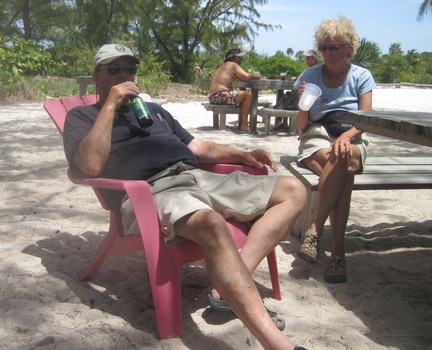
At the Chat 'N Chill beach across from Georgetown. Dick comtemplates the singular lack of bikinis on the beach while Mike comtemplates where in the heck her drinkie went to!
April 11, 2010 23.29.000 75.48.0000 Georgetown, Bahamas
A few interesting days traveling here from Provo, here they are...
April 7, ..... Left very early to check in with Bahamas Customs at Mayaguana Island, however we had rather high winds and seas which means under sail we were moving.... at times over 11 knots. Now to power boaters such as us 11 knots is just a quick troll but to sailboaters thats really quick! We were having so much fun we decided to skip that island and go on to Matthes town to check in, which meant another over night sail.
April 8, ..... In the middle of the night, as we sailed on, we witnessed a helicopter rescue by the coast guard of a patient from a large ship all via the VHF radio. Way off in the distance we could see a cruise ship (they are hard to miss, a huge mountain of light) and we assume that is where the action was. We arrived mid day and John went in to see about customs, which apparently has to drive down here from the main airport. Even with the less than helpful attitude of the marina here we did arrange to clear in, which we did late afternoon. We then walked into town for a bit of (yes!) shopping. Alas, the town seems to be closed up rather permanently. Wonderful, once again we get to save money (except of course for the bar at the marina... we do not consider that a form of shopping)!
April 9, .... Lifted anchor after breakfast and headed north to Rum Cay an easy sail for the day. Arrived mid afternoon and once again foiled in any attempt at shopping. It is beginning to seem as though all these islands are being abandoned. Very strange. The is supposed to be a new marina/resort complex being built just west of where we are anchored however there is zero activity there, and little evidence of any work. Once again we save a ton of money by being unable to shop! Tomorrow we shall head out to Georgetown where we assured by most folks that we will be quickly separated from our cash.
April 10........... Off early to Georgetown, it is a one day sail.
April 11 ........ and a easy sail it was, since half of it was by the “Iron Jenny”, motoring that is. Georgetown is a very crowded place particularly compared to where we have been in the outer Bahamas. It is a bit like going from Roylite Nev. to New York NY! I am sure when we get to Ft. Lauderdale it will be a major shock for us. We are currently sitting at the St. Francis Marina across from Georgetown having a few beers, lunch and allowing John to watch the end of the masters on the cable TV. We will post this and update everything and post we hope tomorrow to get everything up to date. Once we leave here we will not be able to get back online for some days.
April 6, 2010 21.7607N 72.2240W
South Side Marina, “Provo”, Turks & Caicos Islands.
Have spend the night and most of
yesterday here at a very pleasant marina with more than helpful,
friendly hosts: Simon and Charlyn Anderson. Many thanks for the tour
and transportation to a real “dining out” lunch and to the
grocery. There is a very big grocery store here and we knocked
ourselves out provisioning for the next six days. The store was just
like being back in the states, and had the best selection of goods
since leaving St. Thomas. Major shopping spree! The ladies are most
pleased.
 Mike at lunch in Provo
It was interesting to see all the big new condo/resort developments on the north shore of the island many of which, like Miami, are empty. The real estate bust hit here just as hard as it did in Florida. The situation with the government, or lack there of, is not helping the situation. Seems all of the politicians got caught with their hands deep in the cookie jar and Britain is sort of taking back control. Seems the kids took the tax money itself... wrong way.... you have to do it the U.S. way: take the money from the corporations you give the tax money to. More happy people that way!
 Fatdash resting at the South Side Marina, "Provo".
We are going to hang around here while we wait for the propane and to check out with customs for an early departure tomorrow for the Bahamas. We will be out of range of the net for perhaps a week, so as Simon might say: tootles for now!
April 2, 2010 21.1948N 71.252W Big Sandi Cay, Turks & Cacos Islands
We have sailed from Frejardo Puerto
Rico direct to Big Sand Cay in the Turks & Caicos Islands in one
shot. Seventy Nine hours non-stop, a total of 408.5 Naut. Mi. a great
portion of it sailing in what seemed to be the inside of a washing
machine which aptly demonstrates the fact that you can not walk about
a small vessel in such seas, you are in fact simply hurled from place
to place at the whim of the waves. You can only hope to be hurled in
the general direction in which you wish to go. Another lesson learned
is that being terrorized over and over again can become boring.
 Our last rest in Puerto Rico before heading north!
April 3, 2010 21.2950N 71.3200W CockBurn Harbor, Turks & Cacos Islands
We arrived at Cockburn Harbor on South
Caicos and checked into customs then immigration (separate steps)
both completed with very nice people in the apparently only grocery
store on the island. The guide books tell of a marina here where
diesel is available, however the marina is no longer. This was also
the case along the west side of Puerto Rico. We must find fuel soon
as we are having to motor over the shallow banks which now extend for
thirty miles or more. We will spend the night here and leave for
“Provo” on the northwest side of Caicos Bank. We hope to find
fuel and groceries there.... maybe even WiFi to send this to the web
site and check the Email.
 Checked in at the store on left. What is left of the marina are the two gas pumps at the next building.
April 4 2010 21.7421N 72.2904W
Provo, Turks and Caicos
Arrived mid-afternoon after an
interesting (and bumpy) cruise through the shallow flats of the
Caicos Bank, dodging coral heads as we went. One nice thing to be
said about this area from Puerto Rico to Provo is that there is no
shopping! What were supposed to be towns with marinas and stuff were
in fact, so far, not much of anything. We are saving tons of money!
The girls have high hopes for Provo and another rather long list.
Tomorrow we shall go to the marina (we are assured it exists) to fuel
up, buy supplies, wi-fi and check out with the government (if it
exists.... we understand the government here resigned the other day
...)
April 5, 2010 21.7421N 72.2904W
Provo, Turks and Caicos
Weather rather cool for the tropics,
something is going on. In a little while we will head into Provo for
shopping... oh joy. There goes all the cash we saved since Puerto
Rico! We were on the hook here in Sapodilla Bay last night and shall
be here tonight before jumping off for the Bahamas. We all slept in
very late this morning (a delayed reaction to all those night shifts
getting here) so will be getting a late start on the shopping. Sure
hope the marina has diesel! Also hope we find Wi-Fi as we will be in
the wilderness for five to six days after leaving Provo. Next posting
will be from Georgetown in the Bahamas.
March 30 2010 18.2866N 65.6322W Puerto del Rey, Puerto Rico
Today we start the trip to the Bahamas,
by sailing around the southern coast of Puerto Rico to Boqueron our
jumping off place for the two to three day sail to the Turks and
Caicos islands. Todays trip will take just a day and a night a good
trial for the long sail to follow.
Yesterday in Fajardo we literally
“shopped till we dropped” in provisioning the boat for the next
several weeks. Food is quite affordable here in Puerto Rico (Econo
Food Store) but the liquor prices are worse than in Washington (we
did not think that was possible but it is!). We are plugged into the
marinas water system here and so we are thus indulging in very long
showers, and is that a treat!
Time to post this and say goodbye for a
while, we will be away from the net for some time (perhaps one to two
weeks ... unless there is WiFi in Boqueron) as we work our way up to the Bahamas.
Below the pink building on the left.... Lunch in Culebra at Mamacitas "on the water".....
March 28 2010 - Finaly at a WiFi location, here are the posts from the last few days.....
March 22 2010 18.3426N 64.7884W
Caneel Bay St. John Island.
Spent the night here on a National Park
mooring (our Golden Eagle pass makes this very cheap) so we could all
get on line and pay bills and check in with the world. Water maker is
not working ... we will meet up with the water maker tech guy over at
Christmas Cove later today.
March 23 2010 18.3112N 64.8316W
Christmas Cove St. James Island
The water man came, he saw, he
conquered! We are making water! We can shower! There is much joy....
temporarily, as there is a pump on the water maker about to go toast
on us so he has ordered one from California to arrive and install
Wednesday after which we are good to go north.... at last.
Today then, we really have nothing to
do... except of course go ... yes indeed .... shopping! And take
showers, glorious, wondrous showers! Water man, we love you!
March 24 2010 18.3112N 64.8316W
Christmas Cove St. James Island
Bad news day ... The pump arrived too
late to install today. The waterman will be here tomorrow morning.
Otherwise it's laying in the sun, reading and not shopping. We have a
boat anchored next to us which is inhabited by nudists...
Unfortunately they are elder nudists... Hey folks, at some point you
gotta give it up, It ain't cute no more!
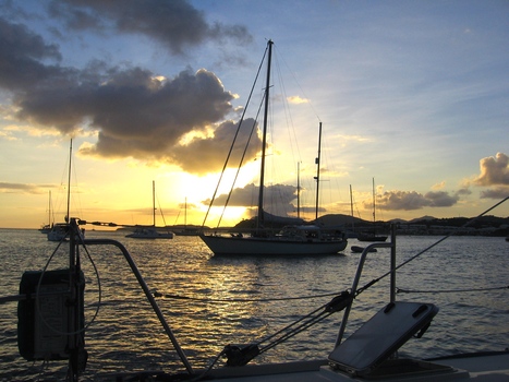 Sunset at Christmas Cove
March 25 2010 18.3112N 64.8316W
Christmas Cove St. James Island
The waterman is here! The pump is in by
noon but there is an air leak somewhere and he and John are
desperately trying to find the source and repair it. In any event it
will be tomorrow or later before we can head north to Puerto Rico. In
the meantime the shopping list grows.
March 25 2010 18.3112N 64.8316W
Christmas Cove St. James Island
The sun set last night with the air
leak continuing ... Chuck “the waterman” will be here shortly
this morning to effect one last try at resolving the problem. We are
proceeding to Culebra whether or not the air bubbles persist. We are
able to make water (if not properly) and that is the main thing.
A major port is soon to be required as
the empty space in the refrigerator grows as does the shopping list.
Starvation rations are perhaps as near as three days away. O.K. maybe
not starvation but we may have to drop the term “gourmet” from
the menu. Horrors!
As usual it should be a good day to
sail... everyday we have 15knot winds (trade winds), four foot seas,
85 degrees and the occasional light rain shower which lasts but a few
minutes.
 Mike & Sandi fight off the aft sunshade
March 27 2010 18.3127N 65.2322W S.W.
Anchorage Isla Culebrita Puerto Rico
Yesterday we were able to repair the
water maker as well as it is going to get. It is making water with
gusto, but with a higher salinity level (600 ppm) than preferred. We
then ran over to Charlette Amalie for the night and with hopes of
getting online.... no luck there. We did however get to enjoy some
very loud calypso music from a waterfront bar until late night.
Quite early this morning we set sail
for Culebra where we arrived in time for lunch after checking in with
customs and a bit of emergency (we ran out of wine) food shopping.
With all the aircraft activity at Culebra we sailed further north to
Isla Culebrita to spend the night. Being in clean sea water the water
maker is running amuck and we are showering like crazy. (The longer
you run the water maker the better the drinking water gets). Time now
to relax and plan our trip along the south coast of Puerto Rico and to the
Bahamas after provisioning in Fajardo on the east coast of Puerto
Rico.
Sandi and Mike found their spot on Peter Island!

March
22 2010 18.3426N 64.7884W Caneel Bay St. John
Island.
Moved this morning to Caneel Bay to get on line and post this update........
March 19, 2010 [ A.M. ] 18.5104N
64.3873W Leverick Bay
Laundry done yesterday while we lounged
about the pool at the Leverick Bay Resort. By renting a mooring for
last night we have free reign of the resort, very cool for $25. Met
some other owners of the same make of boat as the one we are on...
Mary Ann and Phil .... They and John and Sandi traded war stories
about the boats and all the things that get fixed. An on going
battle for all boat owners. Otherwise a quiet restful day.
Today we will be leaving to return to
the US Virgins and will be away from the net for some days. May not
be back on line until early next week .... we hope.
Mar 19 2010 [P.M. ] 18.3573N 64.5699W Deadman Bay
Peter Island, BVI
Fantastic sailing all day to 4:00p
where we arrived off Peter Island for the night.
Trouble with the water maker? It shows
high salinity but it is making water though of suspect quality. Cards
again tonight w/ Dale & Gary who have arrived in the same
anchorage. This will be perhaps the last time we see them.
Mar 20 2010 18.3573N 64.5699W Deadman
Bay Peter Island, BVI
Read all day. Very lazy day for all
except John who worked on water maker all day. At the end, the water
maker does not work. We will need professional help.
Mar
21 18.3638N 64.7463W Francis Bay
St. John Island.
Water Rationing! We are down to one
half tank.
Hiked over to the Peter Island
resort... very nice, very strict dress code, without the proper
clothes you can not eat, we would starve.
The
afternoon we sailed on Jib only to
Sopers Hole to check out of BVi and then on to St. Johns and the US
Virgins where we hope tomorrow to get the water maker fixed so we
can move on to the Spanish Virgins and Puerto Rico. We would be
getting rather behind schedule, if we had one, but we don't so we
aren't.
March 18, 2010 18.5105N 64.3873W Gorda Sound (NW anchorage)
Great
day yesterday.... we basically
did not much of anything. Did a late lunch at the Bitter End
Resort(eliminating the need for dinner) and followed that up with a
mercifully brief bit of shopping. For sundowners we popped over to
“Sognare” and played a few rounds of a, new to us, game called
Cribbage where those in the know seem to make up the rules as we went
along.
We have a bit more shopping today at
Leverick Bay (I see the ladies working on a list) and we will get the
laundry done, all the while lounging around the pool and enjoying a
pain killer or two. Going to be another tough day, I can see it
coming.
 The
car ferry to St. John. Yes, those are live palm trees on the boat!
The
car ferry to St. John. Yes, those are live palm trees on the boat!March 17, 2010 18.5107N 64.3633W Eustacia Sound Virgin Gorda
Yesterday
was a long motor cruise to
Eustacia Sound .... still no wind, very weird. Sandi and John did a
bit of snorkeling while Mike read and Dick tended to the sunburn
acquired while piloting the boat to Jost Van Dyke the other day.
Ouch! Had a nice cocktail hour (or two) over on the “Sognare”
where we learned about all the great places to visit in the Spanish
Virgin Islands off Puerto Rico.
Last night the wind came back and so
did the north swell so we were rocking and rolling all night long.
This morning we pulled anchor early and ducked into Gorda Sound near
Saba Rock (I'll be posting this from the Saba Rock Bar) to cook
breakfast and get caught up with a few chores. There are three large
resorts near us so today I expect more ..... Shopping!
March 16 2010 18.4433N 64.7515W Great Harbor Jost VanDyke (Foxys)
I
was right.... we checked in yesterday
in Sopers Hole and after, sure enough, we immediately went shopping!
In two super markets! (and still did not find everything we needed
for the larder).
We then headed over to Jost Van Dyke (by motor, there is no wind and it
looks more like Lake Shasta than
the sea). We popped into White Bay for a visit to the Soggy Doll or
Bar. What a zoo! A cruse ship from Club Med was in the bay which
filled the beach with “pod people”. There was a full time bikini
alert, however let me be clear: Some of you people should not be
wearing those things!! Particularly you guys!!
From the Soggy Dolor we headed over to
Foxys in Great Harbor to spend the night (the harbor not the bar,
though tempting). We said hi to Foxy and ...... went shopping!
March 15 2010 18.3660N 64.7230W Waterlemon Bay, St. John Island.
As
you can see from the GPS
co-ordinates we did not move very far yesterday. And I was quite
right in that we were once again dragged ashore for a little two mile
hike, only a bit uphill to, incredibly enough, not go shopping! Yes I
know, it's unbelievable, no shopping yesterday! After an exhausting
hike, as we did the day before, we went snorkeling around a small
island so that by the end of the afternoon we are totally done in. At
this rate, we will soon be considering the murder of the activities
director. The day ended on a high note as we fixed Dan's meat candy
which was as usual fantastic. You would think 800 pounds of meat
would be enough for four but when it's meat candy you would be wrong.
Shopping Alert: Today we are going over
to Sopers Hole to clear into the British Virgins and I am sure the
girls have another shopping list going. After shopping we will head
over to Foxys on Jost van Dyke for the night. Perhaps our most
strenuous exercise will be the swim over to the Soggy Dollar Bar, let
us hope so.
March 14 2010 18.3638N 64.7463W Francis Bay St. John Island.
Boy.. I was certainly
wrong about
yesterday. Instead of doing nothing we popped over to an “Eco”
resort located on the bay [ The “Eco” part, seems to me, to be a
code word for tent cabins... get this... without bath rooms! ]. From
the beach we hiked for miles up a stairway (the resort is located on
a vertical slope, must be part of that “Eco” thing).
<pix>
The purpose of this strenuous, muscle destroying assent? You are not
going to believe this.... the purpose was to go shopping!!! Seems we
mis-calculated our egg count. We needed more eggs and for this we
have to hike up the side of a vertical mountain! Two lessons learned,
one: count your eggs more than once, two: beware of “Eco”.
Today we
plan to move on up the coast
for one night before going to the BVI. I do hope it's less
mountainous as I am sure we will be dragged ashore once again.
Probably for more shopping!
March 13 2010 18.3638N 64.7463W Francis Bay St. John Island.
Yesterday
morning it was up early and
off for a lengthy dingy trip Cruz Bay. After a visit to U.S. customs
to obtain our “in & out” card and a visit to the V.I. National
Park museum followed by a rather nice lunch at a local deli
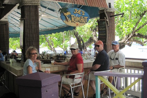
it was off to the ferry dock .... but first, a visit to “Bob's Rum
Hut” was required....
Then
off to Red Hook by ferry, followed
by a strenuous hike up the hill and (are you ready for this folks?)
we went shopping! All sorts of trial and trouble to go shopping....
again! All this followed by another ferry ride and long wet dingy
trip back to the boat.The highlight of the day was when Sandi
demonstrated for us the proper way to macerate and most importantly
to do so only at an unobtrusive time! This was immediately followed
by cocktails. Yes indeed a good day overall!
Today we plan on even more fun! That is
we plan to do absolutely nothing except soak up the heat and perhaps
a swim to cool off as we await the time for sundowners.
March 12 2010 18.3426N 64.7884W Caneel Bay St. John Island.
Two days of shopping is not enough! We
have to do more! We already have enough food on board for the rest of
the year, the freezer is full, the refrigerator is full, but still we
forgot things we need... not an uncommon event for us these days.
Weather is of course wonderful even the middle of the night rain
which smacks you in the face, in bed, through the hatch. The
conundrum is close hatch, hot and stuffy cabin; open hatch, cool and
wet cabin ... open, close, open, close.....
We had the pleasure of meeting a local
charter boat Capt. and Mate, Gary and Dale Miller of the cat
“Sognare” who joined us for sundowners and stories last night. We
will be meeting up with them again to learn about the Spanish Virgins
(islands people, islands!) where we will be heading in a week or so
on the way to Puerto Rico (Where we plan to shop for even more
food!).
Time to start another warm tropical day
in paradise .... to those of you back in Seattle: “Na, Na, Na!
It was an uneventful flight (the best
kind) but very tiring ... a red-eye always is. Six in the morning in
New York is never a lot of fun, especially when the Starbucks is
closed. Somehow we managed to survive and proceed to the flight to
St. Thomas.
Post baggage claim in Charlotte Amalie
we immediately set off to provision the boat, spending the rest of
the day shopping, shopping, shopping. This morning we will again be
shopping, shopping, shopping. We may have enough food on-board to
last normal people to the end of the year. Not being normal we just
may make it to the next island (Bear in mind that a major food
component is adult beverages).
It is going to take us at least a day
or two to settle in, get organized and back on line. We will be
up-dating this space then.